Datum
Haven
Aankomst
Vertrek
23 Aug. 2024
Groenland
-
07:00
Kangerlussuaq is a settlement in western Greenland in the Qeqqata municipality located at the head of the fjord of the same name (Danish: Søndre Strømfjord). It is Greenland’s main air transport hub and the site of Greenland’s largest commercial airport. The airport dates from American settlement during and after World War II, when the site was known as Bluie West-8 and Sondrestrom Air Base. The Kangerlussuaq area is also home to Greenland’s most diverse terrestrial fauna, including muskoxen, caribou, and gyrfalcons. View less
The settlement’s economy and population of 512 is almost entirely reliant on the airport and tourist industry.
24 Aug. 2024
Groenland
05:45
12:00
Kangaamiut (the People of the Fjords) is a settlement which clings to the shoreline of Greenland’s Arctic Circle region, backed by some of the country’s most spectacular fjordlands. The nearby pinnacle-shaped mountains gave the Danish-Norwegian colonial settlement its original name of Sukkertoppen (Sugarloaf) and the town recently celebrated its 250th anniversary. Here, one can experience small-town Greenlandic culture at its most authentic. The town is scattered across a small hill, displaying all the colourful buildings of the town at once; it is impossible to take a bad photo here. View less
A system of staircases and boardwalks leads to the top of the hill, an area used to helicopter transport which offers jaw-dropping vistas of the wilderness around the settlement. The locals are proud of their Inuit history and culture, and the people of Kangaamiut are friendly and welcoming to vistors. Depending on the day, one could see local men selling fresh fish or reindeer meat from the surrounding fjords or flensing their catch on the rocks of the harbour, local women selling intricate homemade beaded necklaces and carvings, or even be invited into a local home to share a pot of coffee with some of the friendly residents, who are always happy to have visitors. Although the scenery is world-class, as in many towns in Greenland, wonderful memories of the welcoming residents are the most treasured.
24 Aug. 2024
Groenland
14:00
19:00
Evighedsfjord (Eternity Fjord) is a large fjord northeast of Kangaamiut in southwest Greenland. The fjord has a length of 75 kilometers and several branches with numerous glaciers coming down from the Maniitsoq Ice Cap to the north can be seen. The Evighedsfjord has several bends and whenever the ship reaches the supposed end the fjord continues in another direction and seems to go on forever. Qingua Kujatdleq Glacier is at its southeastern end.
At the northwestern end a U-shaped valley has seven glaciers coming down from the mountains but not reaching the water. The glaciers had their maximum extent around the year 1870 and have gone through several cycles of advance and retreat. The mountains on either side of the fjord can reach in excess of 2,000 meters and the fjord has a depth of up to 700 meters. Evighedsfjord’s snowline is at 1,100 meters and the Evighedsfjord region is famous as one of Greenland’s best heli-skiing areas.
25 Aug. 2024
Groenland
06:00
17:00
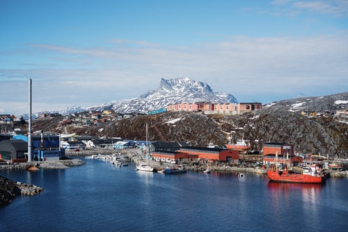
Nuuk, voorheen bekend als Gothab, is de moderne hoofdstad van Groenland, met een universiteit, cafés, musea, bussen en winkels. Wanneer je in deze kleine metropool van 14.000 bent, zul je merken dat je nooit ver van de natuur-arenden glijdt majestueus over gletsjerpieken, en late, late zonsondergangen worden verlicht door het mysterieuze noorderlicht.
26 Aug. 2024
Groenland
08:15
17:00
Sisimiut (‘The People of the Fox Holes’) is Greenland’s second city, the largest Arctic City in North America, and a hub between the warmer South and the frozen North of the country. With a young, dynamic population, including students from all over the country, Sisimiut is one of the fastest growing cities in Greenland. View less
Inhabited for more than four and a half thousand years, the Danish Colonial Era saw the rapid development of the city into a trade centre, and the old buildings and artefacts can be seen at Sisimiut Museum, a collection of beautifully restored buildings displaying everything from ancient turf houses to modern Inuit art. The local artisans are considered some of the best in Greenland, and often sell their wares direct from their communal workshop in the harbour, where they barter with hunters for raw materials. Today, modern industry focussed on processing sea food and shipping; KNI, the state-run chain of general stores operating in even the most remote settlements is based in Sisimiut. Most residents still live in the colourful wooden houses Greenland is so well known for. Sisimiut’s vast back country offers excellent opportunities for hiking and fishing, and the locals often use sled dogs or snowmobiles to get around their vast mountainous playground during the long winters. In the summer, one can walk as far as Kangerlussuaq International Airport, a trail also used for the gruelling Polar Circle Marathon, one of the toughest endurance events in the world.
27 Aug. 2024
Illulisat
06:30
17:30
Known as the birthplace of icebergs, the Ilulissat Icefjord produces nearly 20 million tons of ice each day. In fact, the word Ilulissat means “icebergs” in the Kalaallisut language. The town of Ilulissat is known for its long periods of calm and settled weather, but the climate tends to be cold due to its proximity to the fjord. Approximately 4,500 people live in Ilulissat, the third-largest town in Greenland after Nuuk and Sisimiut. View less Some people here estimate that there are nearly as many sled dogs as human beings living in the town that also boasts a local history museum located in the former home of Greenlandic folk hero and famed polar explorer Knud Rasmussen.
29 Aug. 2024
Pond Inlet, Nunavut, Canada
12:30
19:00
Located in northern Baffin Island Pond Inlet is a small predo¬minantly Inuit community with a population of roughly 1 ,500 inhabitants. In 1818 the British explorer John Ross named a bay in the vicinity after the English astronomer John Pond. Today Pond Inlet is considered one of Canada‘s “jewels of the North” thanks to several picturesque glaciers and mountain ranges nearby. Many archaeological sites of ancient Dorset and Thule peoples can be found near Pond Inlet. View less The Inuit hunted caribou, ringed and harp seals, fish, polar bears, and walrus, as well as narwhals, geese, ptarmigans and Arctic hares long before European and American whalers came here to harvest bowhead whales. Pond Inlet is also known as a major center of Inuit art especially the printmaking and stone carving.
30 Aug. 2024
Dundas Harbour, Devon Island, Nunavut, Canada
07:30
14:00
Austere, remote and a rather severe, Devon Island is as close the closest thing to Mars on planet Earth. The rocky terrain, dry, cold climate and 14-mile wide crater on the north of the island have made it home for a team of research scientists from NASA, who live in the small research station during the Arctic summer. Other than these few men and women, Devon Island is completely unpeopled, and the largest uninhabited island in the world.
There was human habitation as recently as 1951, when a Canadian Mounted Police post that had been on the island since 1924 to monitor illegal activities such as whaling closed. At 320 miles long and 80–100 miles wide, it is the largest of the Parry Islands. Dundas Harbour is found in the south of the island. Then island is set in the icy Arctic Ocean, south of Ellesmere Island and west of Baffin Bay. This make it Canada’s sixth largest island. Discovered by English explorer William Baffin in 1616, the island did not make it on to any maps until William Edward Parry’s exploration of the Arctic in 1820. Despite the desolate conditions, the island does show signs of having sustained human life as many as 3,000 years ago, with the remains of a Thule settlement dating back to 1000 A.D., including tent rings, middens and a gravesite providing testament to the fact. The island is named Talluruti in local Inuktitut language, literally translating as “a woman’s chin with tattoos on it”, as from a distance the deep crevasses resemble traditional facial tattoos.
31 Aug. 2024
Radsock Bay,Devon Island
06:30
12:00
31 Aug. 2024
Beechey Island
13:30
22:00
Beechey Island is a small island off the southwest coast of Devon Island, separated by a narrow waterway called the Barrow Strait. Captain William Edward Parry was the first European to visit the island in 1819. His lieutenant, Frederick William Beechey, named the island after his father, the artist William Beechey (1753–1839). Beechey Island played a significant role in the history of Arctic Exploration. During the winter of 1845-46, Sir John Franklin and his men camped on the island as part of their ill-fated quest to find the Northwest Passage. Mummified remains of three of Franklin’s crew were discovered, giving a better understanding of what happened before the disappearance of the expedition. In 1850 Edward Belcher used the island as a base while surveying the area. Later, in 1903, Norwegian explorer Roald Amundsen stopped at the island at the beginning of his successful voyage in search for the Northwest Passage. Subsequently, Beechey Island has been declared a “Territorial Historic Site” by the Northwest Territories government in 1975 and a National Historic Site of Canada in 1993. It now is part of Nunavut.
1 Sep. 2024
Vastberaden
06:00
18:00
Resolute is one of the northernmost communities in Nunavut and Canada with slightly more than 240 inhabitants. The name goes back to HMS Resolute which was trapped and abandoned in the ice in 1850 while searching for traces of the lost Franklin Expedition. On the southern coast of Cornwallis Island it has long winters and as such is known as Qausuittuq (place with no dawn) –with darkness from early November to early February. View less Although Pre-Dorset, Dorset and Thule remains indicate the area had been used for some 2,500 years, it was only in 1953 and the government enforced High Arctic relocation of Inuit that residents were not related to the weather station or the Royal Canadian Air Force base. Immediately north of Resolute’s strategically important airport is Tupirvik Territorial Park where fossils can be found on the beach, a former old seabed. The waters south of Resolute are part of the core area for migrating beluga whales, while neighboring Bathurst Island has the Polar Bear Pass National Wildlife Area, permitting polar bear travel in spring and summer. Rocky coastal bluffs, rolling hills, moraines and small lakes are habitat for arctic birds, including King Eider Ducks and Greater Snow Geese.
2 Sep. 2024
Cruise Peel Sound
-
-
Peel Sound is a 30 mile wide, 125 mile long channel separating Prince of Wales Island to the west and Somerset Island to the east. It was named in 1851 by explorer Vice Admiral Horatio Austin in honour of Sir Robert Peel, a former prime minister of Great Britain. Austin, however, was not the first person to sail through the sound. Five years earlier, in 1846, Sir John Franklin had passed through the strait, just before his ships became icebound. Peel Sound is not always open. Several explorers, including Francis Leopold McClintock in 1858 and Allen Young in 1875, were unable to pass because it was blocked by ice.
3 Sep. 2024
Nuvanut
12:30
18:00
4 Sep. 2024
Jenny Lind Island, Nunavut, Canada
14:00
20:00
Southeast of Victoria Island and in Queen Maud Gulf, Jenny Lind Island is roughly 20 kilometers in diameter and covers an area of 420 square kilometers. The uninhabited island is named after a famous Scandinavian opera singer and was put on European maps in 1851 when Dr. John Rae of the Hudson’s Bay Company was searching the Canadian Arctic for indications of the fate of Sir John Franklin’s Northwest Passage Expedition. View less The island is a Canadian Important Bird Area with large numbers of Lesser Snow Geese and Ross’s Geese breeding there and a Key Migratory Bird Terrestrial Habitat recognized by the Canadian Wildlife Service. The island has a mix of flat and undulating terrain with low-lying wetlands and sedge meadows and supports a small herd of muskoxen. The island has been the site of a Distant Early Warning Line radar station until the 1990s and still is part of the North Warn System.
5 Sep. 2024
Cambridge Bay, Nunavut, Canada
08:30
18:00
The area around Cambridge Bay was seasonally used by Pre-Dorset, Dorset, Thule, and Copper Inuit to hunt and fish. It was only after the Royal Canadian Mounted Police and the Hudson’s Bay Company decided to set up posts on Victoria Island in the 1920s that outsiders settled, while the Inuit community only came to live at Cambridge Bay in a more permanent way after World War II when a LORAN tower was built. Today Cambridge Bay is one of Canada’s northernmost villages with close to 1,800 residents. It is the administrative center for the Kitikmeot region and an important transportation hub for cargo by sea and air. Arctic char, which is caught in rivers nearby, is Cambridge Bay’s major export article. For many years Cambridge Bay was the home to Roald Amundsen’s ship Maud. Having served in the Arctic for several years, the ship was brought to Cambridge Bay by the Hudson’s Bay Company where she was beset by ice in 1926 and sank in 1930. The Maud was eventually raised and transported to Norway where she is to be exhibited in a museum.
6 Sep. 2024
Cruise Dease Strait
-
-
Found north of Kent Peninsula and south of Victoria Island, Nunavut’s roughly 160 kilometer long Dease Strait was named after Peter Warren Dease of the Hudson Bay Company. Sir John Franklin, who had been sent on an early attempt to map northern Canada and to search for the Northwest Passage, had received useful information from Dease at Fort Chipewyan before heading north during his first expedition. Traveling down the Coppermine River, Franklin then took 3 canoes entering Coronation Gulf heading northeast. Reaching Cape Flinders and continuing on to Point Turnagain in August 1821, he had effectively entered Dease Strait which continues on east to Cambridge Bay, Victoria Strait and Queen Maud Gulf. Seals, white foxes and rabbits were hunted on Kent Peninsula and 73 bird species recorded. Musk oxen as well as the endemic Dolphin and Union Caribou, which are different from the wide-spread Barren-ground caribou, can be occasionally seen on both sides of the strait.
7 Sep. 2024
Cruise Amundsen Through, Canada
-
-
At the northwestern end of Amundsen Gulf and the Northwest Passage, the Amundsen Trough is a submarine glacial trough leading into the Beaufort Sea. South of Banks Island and its Migratory Bird Sanctuary, northeast of the Anderson River Delta Bird Sanctuary, and north of Tuktut Nogait National Park, all within the Northwest Territories, the submarine feature and gulf are named after Roald Amundsen. Plough marks of iceberg keels with a width of up to 150 meters and a depth of up to 10 meters have been identified on the sea floor. Seismic research in 2014 has shown that at least nine Quaternary ice streams advanced through the Amundsen Trough, implying it was a major route for ice and sediment towards the Arctic Ocean.
8 Sep. 2024
Sachs Harbor
06:30
18:00
Sachs Harbour is a small community of some 130 residents on the southwestern side of Banks Island, Canada’s fifth-largest island. It is the only settlement on Banks Island and the northernmost community in the Northwest Territories. The name goes back to the 30-ton schooner Mary Sachs, one of three ships in Stefansson’s Canadian Arctic Expedition 1913-1916. Sachs Harbour is surrounded by the Banks Island Migratory Bird Sanctuary No 1. View less To the west dry mud cliffs can be found, while the tidal mud flats, river deltas, wetland meadows and barren grounds with Dryas are used by some 95% of the Western Arctic’s Lesser Snow Geese, apart from Ross’s Geese, Black Brants, an estimated 25,000 King Eiders, several thousands of Long-tailed Ducks, Tundra Swans and Sandhill Cranes as key species. Banks Island is also home to more than half of the world‘s muskoxen, found mainly on the northern side, and Sachs Harbour has been called the “Muskox Capital of Canada”. For the Inuvialuit Sachs Harbour’s indigenous name is Ikaahuk “Place to which you cross” or “Place where one crosses”. The community was started in 1929, when Inuit families from the Mackenzie River Delta came to settle hunting mainly white foxes.
9 Sep. 2024
Smoking Hills, Northwest Territories, Canada
09:30
13:00
The Northwest Territories’ Smoking Hills show a natural phenomenon which has probably been active for thousands of years. The hills close to the Beaufort Sea were seen by John Franklin in 1826 during his second Canadian expedition looking for indications of a Northwest Passage. Franklin observed that the rocks and soil around Cape Bathurst seemed to be on fire and produced acrid white smoke. They were therefor named “Smoking Hills”. View less The reason behind this phenomenon is neither human-induced burning nor volcanic activity, but the subsurface exothermic reaction between the bituminous shale, the sulfur and the iron pyrite of the area. The heat being released through the oxidation of pyrites in the Cretaceous mudstones along the sea cliffs leads not only to high ground temperatures, but also to hot sulfurous gas being driven off and the possibility of spontaneous combustion. The fumes that are seen contain sulfur dioxide and sulfuric acid and are noxious.
10 Sep. 2024
Cruise Beaufort Sea
-
-
Take advantage of the brief summer thaw and enjoy the spectacular peculiarities of the Beaufort Sea. Frozen for most of the year, the Beaufort Sea is only navigationally possible during the short summer months of August and September when a channel near the Canadian and Alaskan shore opens up. Despite the sea being frozen for a sixth of the year, it is home to a myriad of wildlife, so lucky Northwest Passage travellers will be richly rewarded. Be on deck with binoculars and cameras at the ready for sightings of fish like Arctic char, birds like the king eider, marine mammals like beluga and bowhead whales, and, if you’re lucky, predators like the polar bear. However, circumstances in the rapidly changing Arctic might soon change the species habitations and have many scientists and ecologists are worried that the future of the wildlife of the Beaufort Sea hangs in the balance. Dispute has arisen regarding how long the shores have been populated by humans. Some say that the Beaufort Sea supported human life as long as 30,000 years ago, while others disagree, saying that the livelihoods and cultures of the Inupiat, Inuvialuit and Gwich’in peoples who live on the shores is much more recent. In any case, recorded discovery is less than 200 years old. The sea is named after Sir Francis Beaufort, the British 18th century naval officer whose observation of the wind and sea state resulted in the Beaufort scale.
11 Sep. 2024
Herschel Island
08:30
18:00
Three kilometers off Yukon’s north coast, only Workboat Passage separates Herschel Island-Qikiqtaruk from Ivvavik National Park. The low-lying treeless island of 116 square kilometers was Yukon’s first territorial park. View less Herschel Island-Qikiqtaruk has been declared a National Historic Site of Canada in 1972, classified as a Nature Preserve in 1987, designated a Natural Environment Park in 2002 and as an example of the technologies and techniques used for living and construction over the past several millennia it is now on the tentative UNESCO WHS list! The island is also an important area for Ice Age fossils. Normally snow-covered from September to June, the island shows abundant and diverse wildlife, with many migratory birds, including the largest colony of Black Guillemots in the Western Arctic, caribou, muskox, polar bear, and brown bear on land and bowhead and beluga whales, ringed and bearded seals, and occasionally walrus in its surrounding waters. Seasonal hunting possibilities from spring to fall have led the Inuvialuit using the area for hundreds of years. When Franklin arrived in 1826 he saw three of their camps. Remains of their old dwellings are still visible near Simpson Point. This is where in the late 1800s, American whalers established a now abandoned station. At the height of the Beaufort Sea whale hunting period there were 1,500 residents. Several of the historic buildings by whalers, and later missionaries, traders and the RCMP are still standing –although some had to be moved further inland to escape the rising sea level.
14 Sep. 2024
Point Hope, Alaska
06:30
17:30
Whales dominate life at Point Hope (Tikiġaq) settlement in the extreme Northwest of Alaska. Tikiġaq, the Inuit name of the settlement, means finger. It describes the shape of the point jutting out into the sea upon which the settlement sits. It is a good location for hunting as Bowhead Whales and other marine mammals swim close to the shore as they round the point on migrations. The Inuit people of Point Hope still rely on hunting for much of their food.
15 Sep. 2024
Port Clarence, Alaska
12:00
18:00
16 Sep. 2024
Nome
07:00
-
Nome kreeg zijn populariteit tijdens het Gold Rush-tijdperk toen de Three Lucky Swedes de eersten waren die goud ontdekten in Nome‘s Anvil Creek, en de zoektocht naar goud nog steeds actief is in Nome. Gelegen aan de rand van de Beringstraat en de zuidwestkant van het Seward-schiereiland, heeft dit kleine stadje een levendige eskimocultuur en een aantal van de beste eskimodansen in Alaska. De adembenemende gouden heuvels die Nome omringen herbergen vele soorten watervogels, beren, muskus, os, kariboes en andere dieren in het wild. Er is ook een overvloed aan paaiende zalm die de beken opzwemt. Met zijn stevige zomertemperaturen van gemiddeld halverwege de jaren 50 en perfect heldere lucht is Nome een prachtige plek voor vogelliefhebbers en wandelaars. *Op zoek naar uw rijkdom? Pak een gouden pan en ga op zoek naar goud. Als je klaar bent, maak je een foto met de grootste goudpan in Alaska en de standbeelden van de Three Lucky Swedes. *Ervaar de lokale Eskimocultuur en leer een dansje of twee wanneer je een authentiek Eskimodorp bezoekt. *Geniet van de Wild Flower Excursion om een glimp op te vangen van de 2000+ soorten wilde bloemen die groeien op het Seward Peninsula.Nome kreeg zijn populariteit tijdens het Gold Rush-tijdperk toen de Three Lucky Swedes de eersten waren die goud ontdekten in Nome‘s Anvil Creek, en de zoektocht naar goud nog steeds actief is in Nome. Gelegen aan de rand van de Beringstraat en de zuidwestkant van het Seward-schiereiland, heeft dit kleine stadje een levendige eskimocultuur en een aantal van de beste eskimodansen in Alaska. De adembenemende gouden heuvels die Nome omringen herbergen vele soorten watervogels, beren, muskus, os, kariboes en andere dieren in het wild. Er is ook een overvloed aan paaiende zalm die de beken opzwemt. Met zijn stevige zomertemperaturen van gemiddeld halverwege de jaren 50 en perfect heldere lucht is Nome een prachtige plek voor vogelliefhebbers en wandelaars. *Op zoek naar uw rijkdom? Pak een gouden pan en ga op zoek naar goud. Als je klaar bent, maak je een foto met de grootste goudpan in Alaska en de standbeelden van de Three Lucky Swedes. *Ervaar de lokale Eskimocultuur en leer een dansje of twee wanneer je een authentiek Eskimodorp bezoekt. *Geniet van de Wild Flower Excursion om een glimp op te vangen van de 2000+ soorten wilde bloemen die groeien op het Seward Peninsula.

